 With increased attention on harmful algal and cyanobacteria blooms in lakes, there has been a surge in remote-sensing techniques developed to monitor these blooms. Remote-sensing offers unique advantages to traditional techniques, such as the ability to visualize high resolution spatial and temporal variability of blooms, enabling a better understanding of bloom dynamics.
In 2019, a working group was formed consisting of ALMS, the Pigeon Lake Watershed Association (PLWA), Dr. Rolf Vinebrooke from the University of Alberta, Alberta Environment and Parks, and the Alberta Biodiversity Monitoring Institute (ABMI) to begin utilizing satellite imagery to learn more about algal and cyanobacteria bloom dynamics in Pigeon Lake, Alberta. The project began by assessing Sentinel-2 and Sentinel-3 derived chlorophyll-a concentrations in Pigeon Lake using models developed for lakes outside of Alberta. Chlorophyll-a is a pigment found in all algae and cyanobacteria, and its concentration is lake water is used to indicate the abundance of algae and cyanobacteria.
In the summer of 2020, field samples were taken at Pigeon Lake to provide the data necessary to validate a model specific to Pigeon Lake, for the Sentinel-2 and Sentinel-3 satellites. Upon successful model validation, a prototype visualization tool was developed for Pigeon Lake using a Google Earth Engine web application. The visualization tool allows the app user to visualize the distribution of chlorophyll-a concentrations across Pigeon Lake derived from the imagery collected by Sentinel-2 and Sentinel-3, and to also view true-color imagery of the lake. The tool also enables users to interact with satellite-derived bloom metrics such as average chlorophyll-a concentration across the lake, and to compare these values through an open water season, and between years. The web app is still under development, and will be released to the public once ready.
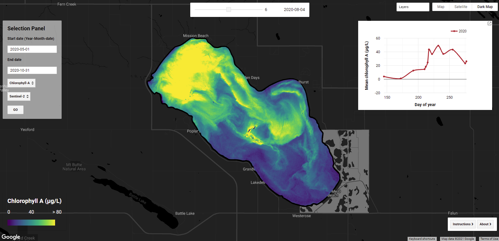
Screenshot of prototype visualization tool, displaying chlorophyll-a concentrations at Pigeon Lake on August 4, 2020.
A current goal of the project is to improve the understanding of algal bloom dynamics at other lakes in Alberta, and to improve the confidence in the integrity of Alberta lake specific chlorophyll-a concentration indices. To address this goal, field samples were collected in the summer of 2021 at Wabamun Lake, Lesser Slave Lake, and Lac La Biche with the assistance of the Wabamun Watershed Management Council (WWMC), Alberta Environment and Parks, the Lesser Slave Watershed Council (LSWC), and Lac La Biche County.
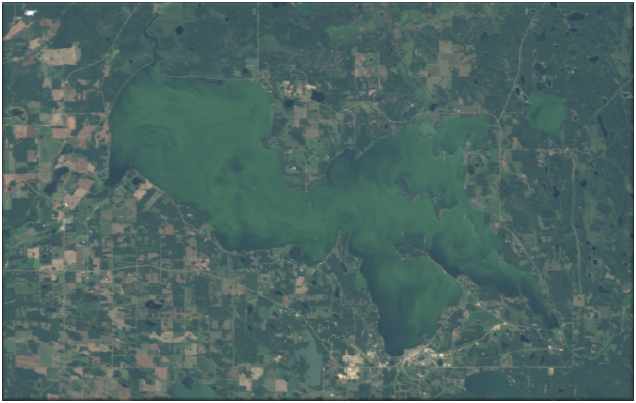
Sentinel-2 satellite imagery of Lac La Biche from August 29, 2021
The trajectory of the project is to develop the visualization tool to enable users to view bloom dynamics in near-real time for multiple lakes in Alberta. The project will also continue to support research into the dynamics of blooms on Alberta lakes, contribute to environmental public health monitoring of blooms, and to provide metrics that enable watershed stewardship groups and government to evaluate lake management initiatives.
Jordyn Lajeunesse, Satellite Technician
 Jordyn’s passion for the outdoors developed growing up in Saskatchewan, spending most of her time at the lakes. She was immersed in numerous activities, including camping, fishing, and other water recreational activities. She continues pursuing outdoor activities like backcountry camping, hiking, and exploring Alberta’s vast nature. She graduated from MacEwan University in 2023 with a B.Sc. majoring in Biology and looks forward to focusing on working with the community and freshwater ecology. She will be working on the Satellite project as a technician in the summer. She looks forward to learning more about algal blooms and using satellite imagery as a visualization tool to understand better algal bloom dynamics and how this varies across Alberta lakes.
 The members of the steering committee will continue to play a strong role in facilitating and tracking implementation actions. This includes any actions they were responsible for, as well as tracking other committees and sector’s actions and progress made towards achieving the plan’s outcomes. Ongoing communication is essential to successful implementation and achieving outcomes, therefore a regular reporting mechanism could be set up in order to provide regular evaluation of the plan.
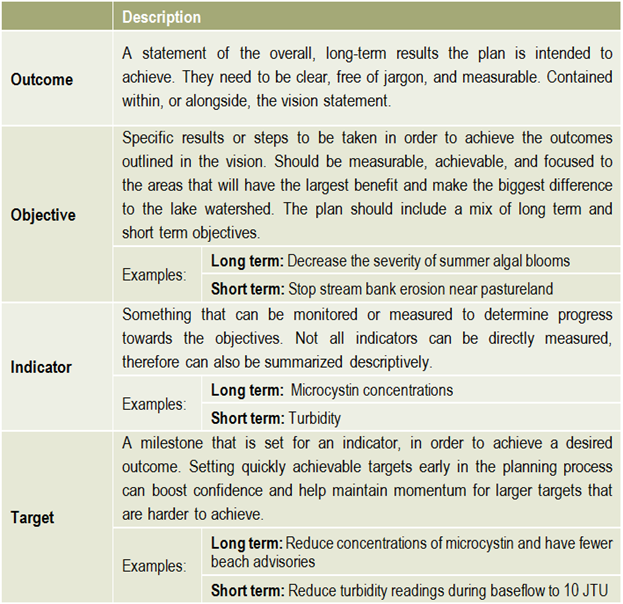
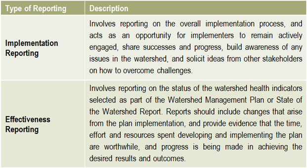 Reporting is an essential component of any watershed management planning and implementation process. There are two main types of reporting that should be shared with stakeholders on a regular basis: implementation reporting & effectiveness reporting.
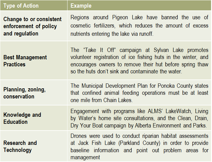 There is no limit to the number or types of lake management actions, but they typically fall into the categories on the right.

 Helpful resources
 The development of a lake watershed management plan provides the guidance needed to implement activities, but the plan cannot be static. Monitoring the performance of your management actions is essential to understanding whether your goals have been met, and whether further actions are needed. Monitoring and evaluating the implementation and effectiveness of a lake watershed management plan allows assessment of progress towards the goals and objectives of the plan, identification of problems and opportunities, and a collection of critical information required when performing a 5 or 10 year review of the plan.
 What has the monitoring results of the plan and of the indicators shown? Is there a need to modify the plan? It is important that the lake watershed management plan does not just sit on a shelf. Information gaps should be addressed, action items need to be managed, completed, and evaluated to best address the needs of the lake. Always keep in mind the vision: if the actions taken are not bringing the lake closer to that vision, then the plan needs to be modified. Consider updating both the state of the watershed and the lake watershed management plans at regular intervals to make sure that the actions taken were achieving the desired outcomes and to evaluate what work still needs to be done.
 Once a plan has been approved by all affected sectors and officially endorsed and released by the steering committee, then implementation can begin in full. Action projects can be large and comprehensive, or made smaller by staging projects over time or into modules that can be tackled one at a time. Fundraising is an issue that many community groups may find intimidating, but experience with programs such as the Pine Lake Restoration Program (see
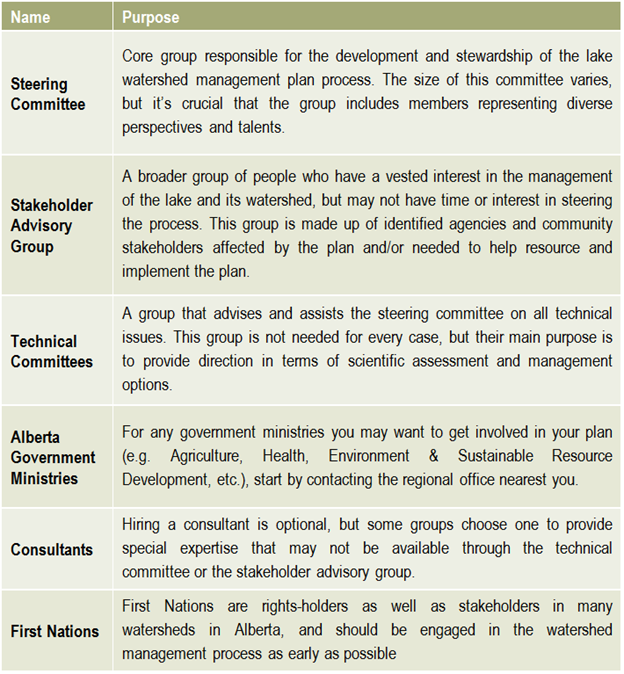
 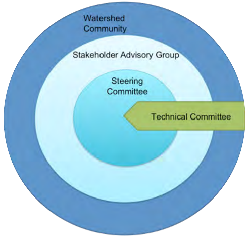 This graphic describes how the various committees and groups will work and interact together. The circle size depicts the approximate number of people involved, and the circles overlapping indicates that some individuals may reside in all of the circles and participate in multiple committees as part of the planning process. The technical committee is shown as an arrow, indicating that it is independent and has relatively few people, and yet it interacts with all of the groups. This graphic may look different depending on the lake and the people involved, and a detailed structure should be agreed upon and described in the plan’s Terms of Reference (Step 6).
Recent Comments