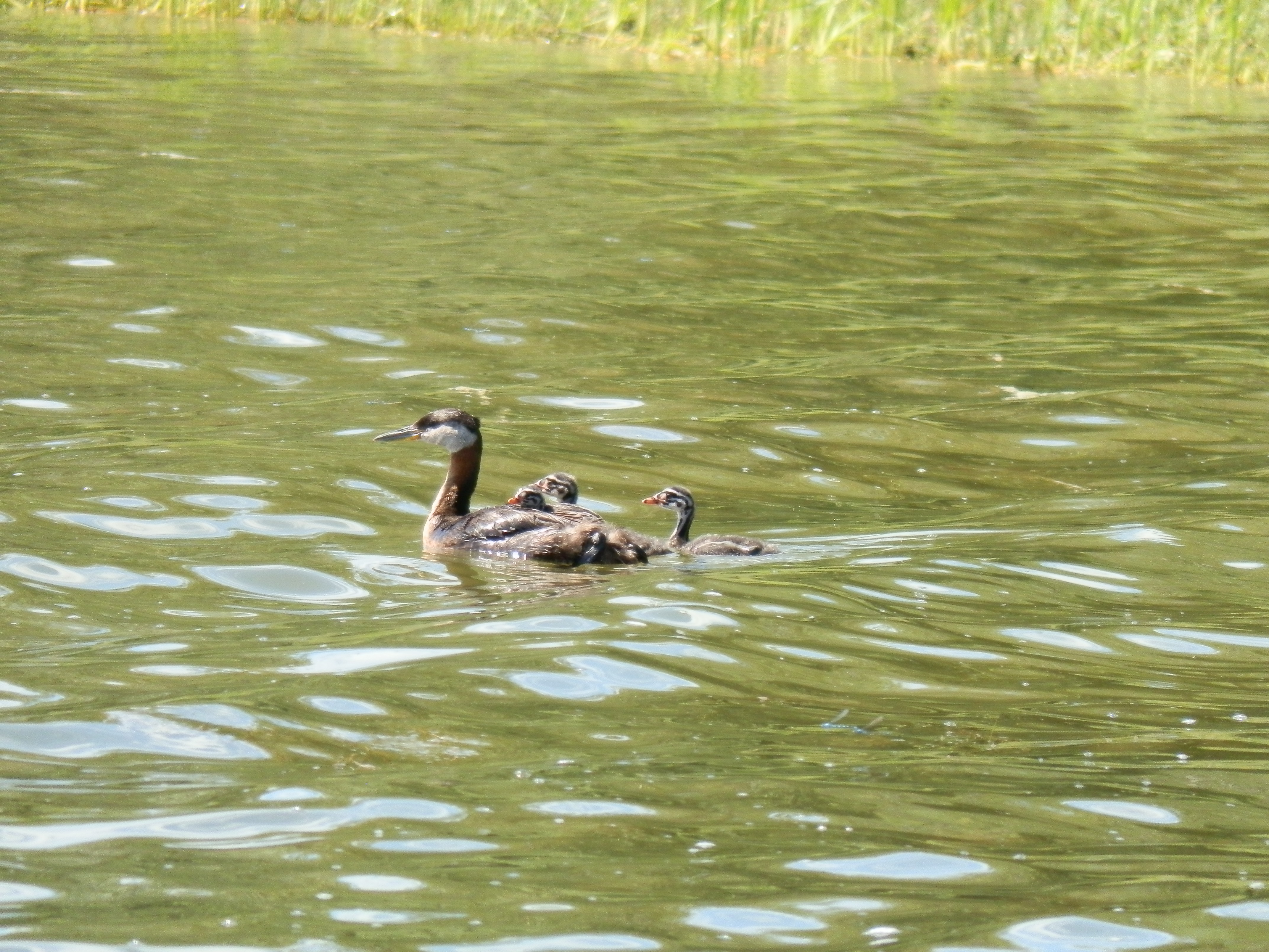
Conserving and managing the valuable lands adjacent to rivers, lakes and wetlands
As development intensifies and land uses change, Alberta’s riparian lands will continue to be lost and degraded without a focused effort to conserve and manage them. Immediately adjacent to rivers and lakes, these lands support productive and diverse animal and plant communities, play an important role in flood and drought mitigation, and are a valuable component of the landscape. Healthy riparian lands provide environmental, economic, cultural and recreational benefits throughout the province.
A new report from the Alberta Water Council makes 13 recommendations for more effective conservation and management of riparian lands in support of Water for Life goals.
Riparian land conservation and management is complex. All levels of government and diverse stakeholders on both public and private land have roles in managing and influencing outcomes on Alberta’s riparian lands. Although many successful programs and policies have been developed, Alberta lacks a broad scale provincial initiative that sets and measures riparian outcomes that are formally supported by all. The report highlights the need for a province-wide assessment to identify how much riparian land exists, what its current state is, and how much has been lost or degraded. Stephanie Neufeld, representing the Lake Environment Conservation Sector on the team explains that “We know scientifically and intuitively that riparian lands are unique and have high ecological and societal value. It’s time to start systematically measuring, monitoring and reporting on riparian health and function at the provincial scale to ensure that these lands remain an integral part of Alberta’s landscape, now and in the future.”
The Council’s Riparian Land Conservation and Management report contains thirteen recommendations that highlight how riparian land conservation and management can be improved in Alberta, and builds on existing and long-term efforts by many individuals and organizations. The report outlines the need to:
- Develop a provincial vision and outcomes for riparian land conservation and management that will allow policies, strategies and initiatives work towards a common goal.
- Adopt accepted methodologies and use them to map riparian lands throughout the province on an ongoing basis.
- Coordinate and collaborate with municipalities to ensure consistent decision making with respect to riparian land conservation and management.
- Share knowledge and information to increase understanding of riparian lands.
- Develop integrated management solutions at all scales.
Norine Ambrose with Cows and Fish represented the Fisheries Habitat Conservation Sector on the team that examined this issue. She notes, “This report is a really significant step forward in riparian management in Alberta, conserving and managing the areas next to water, including floodplains, shores and banks. Riparian areas play such a vital role in water quality and quantity, which includes flood and drought attenuation, supports biological diversity, and contributes to many social and economic values. The recommendations have the consensus of many diverse sectors, which will go a long way toward improving riparian health and management in Alberta. I look forward to collaborating with these sectors in implementing the recommendations.” This multi-sector project included Alberta’s major land and water users who worked to develop an innovative approach to improving riparian land conservation and management in the province.
The report and more information on the Alberta Water Council can be found at www.awchome.ca.
 The members of the steering committee will continue to play a strong role in facilitating and tracking implementation actions. This includes any actions they were responsible for, as well as tracking other committees and sector’s actions and progress made towards achieving the plan’s outcomes. Ongoing communication is essential to successful implementation and achieving outcomes, therefore a regular reporting mechanism could be set up in order to provide regular evaluation of the plan.
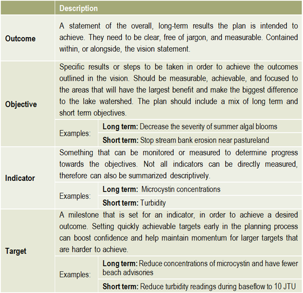
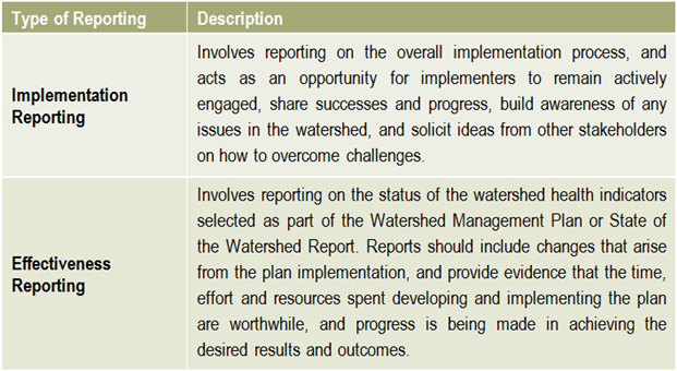 Reporting is an essential component of any watershed management planning and implementation process. There are two main types of reporting that should be shared with stakeholders on a regular basis: implementation reporting & effectiveness reporting.
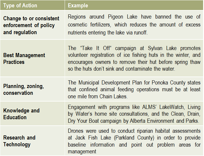 There is no limit to the number or types of lake management actions, but they typically fall into the categories on the right.

 Helpful resources
 The development of a lake watershed management plan provides the guidance needed to implement activities, but the plan cannot be static. Monitoring the performance of your management actions is essential to understanding whether your goals have been met, and whether further actions are needed. Monitoring and evaluating the implementation and effectiveness of a lake watershed management plan allows assessment of progress towards the goals and objectives of the plan, identification of problems and opportunities, and a collection of critical information required when performing a 5 or 10 year review of the plan.
 What has the monitoring results of the plan and of the indicators shown? Is there a need to modify the plan? It is important that the lake watershed management plan does not just sit on a shelf. Information gaps should be addressed, action items need to be managed, completed, and evaluated to best address the needs of the lake. Always keep in mind the vision: if the actions taken are not bringing the lake closer to that vision, then the plan needs to be modified. Consider updating both the state of the watershed and the lake watershed management plans at regular intervals to make sure that the actions taken were achieving the desired outcomes and to evaluate what work still needs to be done.
 Once a plan has been approved by all affected sectors and officially endorsed and released by the steering committee, then implementation can begin in full. Action projects can be large and comprehensive, or made smaller by staging projects over time or into modules that can be tackled one at a time. Fundraising is an issue that many community groups may find intimidating, but experience with programs such as the Pine Lake Restoration Program (see
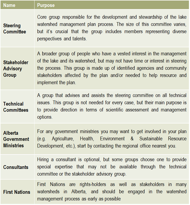
 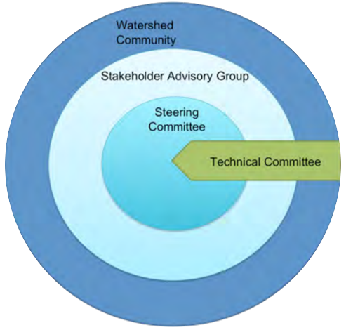 This graphic describes how the various committees and groups will work and interact together. The circle size depicts the approximate number of people involved, and the circles overlapping indicates that some individuals may reside in all of the circles and participate in multiple committees as part of the planning process. The technical committee is shown as an arrow, indicating that it is independent and has relatively few people, and yet it interacts with all of the groups. This graphic may look different depending on the lake and the people involved, and a detailed structure should be agreed upon and described in the plan’s Terms of Reference (Step 6).
Recent Comments